History of the Unit
WASHINGTON’S DILEMMA
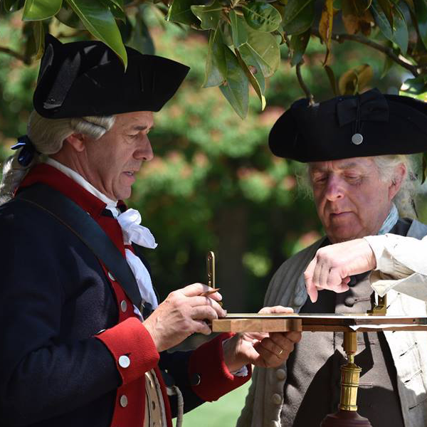
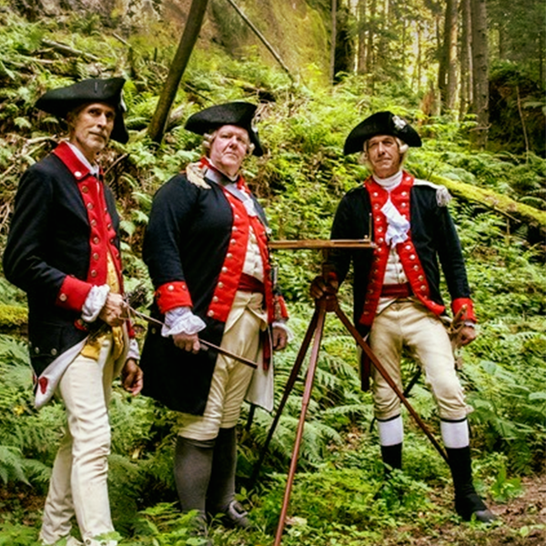
By the summer of 1777, George Washington had identified a definite weakness in the Army’s ability to produce adequate topographical data in order to plan and execute theater operations. In July of that year, Washington wrote to Congress, “A good geographer to Survey the Roads and take Sketches of the Country where the Army is to Act would be extremely useful… …I would beg leave to recommend Mr. Robt. Erskine…”
THE SURVEYOR GENERALS
Robert Erskine, 1777-1780
Robert Erskine was a hydrological engineer who was educated at University of Edinburgh. He invented the “Continual Steam Pump” and “Platometer”, a centrifugal hydraulic engine, and experimented with other hydraulic systems. He became known as an inventor and engineer of some renown in his native land.
In 1771 at the age of 36 he was elected a Fellow of the Royal Society, the oldest known scientific academy in existance for substantial contributions to the improvement of natural knowledge, including mathematics, engineering science, and medical science. That year the owners of an ironworks near Ringwood, New Jersey hired Erskine to revitalize the business as the former ironmaster had nearly bankrupted the operations replace due to profligate spending. Erskine immediately set about trying to make the operation profitable. His efforts were cut short by the American Revolution. Erskine was sympathetic to the American cause, but worried that he might lose his workers to the army. Instead, he organized them into a citizen militia and was appointed as captain in August 1775.
The Continental Army was concerned that British warships would gain control of the Hudson River and separate New England from the rest of the colonies. Erskine designed a tetrahedron-shaped marine cheval-de-frise, a defensive barrier of pointed logs strung together abreast the river to prevent warships from sailing upriver. It was place between Fort Washington on the northern end of Manhattan and Fort Lee, New Jersey in 1776.
Washington was impressed with Erskine from the moment they met in 1777, and appointed him to the post of Geographer and Surveyor General of the Continental Army. In that role Erskine and the men assigned to him drew more than 275 maps covering the northern sector of the war. His maps of the region, showing roads, buildings, and other details, were of much use to General Washington and remain historically valuable today. Erskine also kept the Ringwood ironworks in operation, supplying critical munitions and materials to Washington’s army.
Robert Erskine pasted away on October 2, 1780 after catching a cold (likely pneumonia) while surveying in the Hudson Highlands.
Simeon DeWitt, 1778-1783
De Witt was born in 1756 in Ulster County, New York. He was the only graduate in the class of 1776 at Queens College – now Rutgers College of Rutgers University in New Brunswick, New Jersey. After the capture of New Brunswick by the British during the American Revolution, De Witt fled to New York City where he joined the Continental Army. In June 1778, having been trained as a surveyor by his uncle, General James Clinton, De Witt was appointed as assistant to the Geographer and Surveyor of the Army, Robert Erskine, and aided in the surveying and drafting of numerous, historically significant maps. After Erskine’s death in 1780, Washington appointed to the post of Geographer and Surveyor General.
After the war, De Witt attempted, but failed, to get the Continental Congress interested in a national mapping project.
De Witt was appointed New York State Surveyor General in 1784, New York being one of the few states which had such an office. De Witt died 50 years later still holding that position, having been re-appointed and re-elected several times.
Thomas Hutchins, 1781 – 1783
Hutchins was born in 1730 in New Jersey. At the age of 16 he went to the western country and obtained an appointment as an ensign in the British Army. By 1757 he was commissioned a lieutenant in the colony of Pennsylvania, and a year later he was promoted to quartermaster in Colonel Hugh Mercer’s battalion and was stationed at Fort Duquesne near Pittsburgh.
In 1766, he started working for the British Army as an engineer. That year, Hutchins was a member of an expedition down the Ohio River to survey territory acquired by the 1763 Treaty of Paris. Hutchins worked in the Midwestern territories on land and river surveys for several years until he was transferred to the Southern Department of North America in 1772 surveying western Florida. His advancements in the fields of topography and geography led him to be elected a member of the American Philosophical Society.
Despite his years of service with the British Army, he sympathized with the American cause during the American Revolution. An agent had discovered that Hutchins had been using a secret mailing address and sending coded dispatches. It is not clear if this was espionage or his continued attention to land speculation activities he was involved with in America. Likely suspecting his investigation, Hutchins tried to sell his captaincy in the Regiment. Hutchins resigned from his position in 1780. He was arrested, charged with treason, and imprisoned in a mostly secretive set of events. In 1780, he escaped to France and contacted Benjamin Franklin in the United States with a request to join the Continental Army. In December 1780, Hutchins sailed to Charleston, South Carolina.
In May 1781, Hutchins was appointed Geographer of the Southern Army, and shared duties with Simeon DeWitt, the Geographer of the Continental Army. Shortly afterwards, a new title was granted to both men, Geographer of the United States. When DeWitt became the surveyor-general of New York in 1784, Hutchins held the prestigious title alone.
In 1785, Hutchins became Geographer General and began his biggest assignment- surveying “Seven Ranges” townships in the Northwest Territory (Eastern Ohio) as provided by the Land Ordnance Act of 1785. Hutchins died on assignment while surveying the Seven Ranges in 1789.
THE REQUIREMENTS OF THE DEPARTMENT OF THE GEOGRAPHER
The primary duties of the department was to produce Route Maps in order for the Continental Army to identify the best and safest way to get from one to place to another. Route Maps rarely contained much detail as the surveyor’s attention was paid to the immediate vicinity. Items typically depicted on these maps to assist officers in identifying locations would included defiles, prominences, stream and river crossings, taverns, mills, and other prominent features.
THE SURVEYORS
Upon appointment, Erskine identified to Washington the type of individuals he required to successfully fulfill the duties required of the department:
“Young gentlemen of Mathematical genius, who are acquainted with the principles of Geometry, and who have a taste for drawing, would be the most proper assistants for a Geographer. Such, in a few days practice, may be made expert surveyors. The instrument best adapted for accuracy and dispatch is the Plain-Table; by this, the Surveyor plans as he proceeds, and not having his work to protract in the evening may attend the longer to it in the day. One of these instruments, with a chain and ten iron-shod arrows, should be provided for each of the Surveyors it may be thought proper to employ.”
“A Surveyor who can walk 15 miles a day may plan 5 miles; if the country is open, and stations of considerable length can be obtained, then perhaps greater dispatch can be made”
“The Surveyor, besides attending to the course and measuring the distance of the way he is traversing, should at all convenient places where he can see around him, take observations and angles to Mountains, hills, steeples, houses and other objects which present themselves, in order to fix their site; to correct his work; and to facilitate its being connected with other Surveys.”
– Robert Erskine to George Washington, August 1, 1777
THE SURVEYING PARTY
The personnel that Erskine required for assigning surveying projects consisted of:
- Geographer “General”
- Assistant Geographer
- Draughtsman (Cartographer)
- Civilian Surveyor (contractor)
- Chainman
- Poleman
- Guard
Between four and six officers were attached to the department at any given time.
“To prevent this inconvenience and delay, as men enough can be had from Camp without additional expense, six attendants to each surveyor will be proper; to wit, two Chain-bearers, one to carry the Instrument, and three to hold flag staffs; two flags, indeed, are only wanted in common; but three are necessary for running a straight line with dispatch; and the third flag may be usefully employed in several cases besides.”
– Robert Erskine to George Washington, August 1, 1777
THE LIFE OF A SURVEYOR
Life in Camp
“I wish my friend You had been at Saratoga When they Surrendered The Most glorious grandest Sight America ever beheld or perhaps ever shall see was there to be Seen of which I had the pleasure to be a spectator.”
– Simeon DeWitt to John Bogart, 14 February 1778
“…You Come to where one Mr. Erskine quarters Enter in & you’ll find a confused heap of papers variegated with squares triangles Circles paralellograms & what not…”
– Simeon DeWitt to John Bogart, 1779
“We are now settled at Morristown very cleverly where I expect we shall continue during the Winter And pass the time As agreeably as we can— You know Mr. Tim Ford he and I have got accidentally acquainted with each other And amuse ourselves by speaking composing playing on the flute Smoking together Walking &c.“
– Simeon DeWitt to John Bogart, 10 January 1780
However, it was not always a “Desk Job”
“But before the surrender in the Battles and Battles when they were penned up What Scenes! The Woods on fire, the mountain Belching Smoak and flames The Roaring Artillery Shaking the worlds and us…….we heard a few balls whisle All the Loss our regiment sustained was one man wounded who is since well.”
– Simeon DeWitt to John Bogart, 14 February 1778
“…I had Neither pencel or Indian Ink to Shade the Hills which are Very Numerous…”
“…In good Spirits After a March of Near 300 Miles in such Terrable Weather Almost barefooted & naked. We suffered a good Deal for want of Bread, as we had not any of that usfull Articles for four Days.”
“…two men of our party went out to Search for Some Horses that were Lost, & not minding to take their Arms with them, were fired on from a thicket by some Lurking Indians who wounded one of them (that is Since Dead of the Wound)”
– Capt. William Gray on Col. Butlers’s Raid, 28 October 1778
“I have been cursing the mountains ever since we come to this place because they tire me so much in traveling over them. We have survey’d nothing but the Path and Passes on them. I have worn a piece off my toe in Walking too much it smarted yesterday but today he seems well enough.”
– Simeon DeWitt to John Bogart, 25 July 1779
“Mr. Lodge, a surveyor, with his assistants, without the sentry’s rising, advanced up a hill, were fired upon by a party of Indians who lay concealed on the hill for that purpose. One of his men was wounded, the rest made their escape.”
“This morning the man wounded yesterday dies…”
– Major Jeremiah Fogg, 13 and 14 September 1779
SECRECY AND SECURITY ARE PARAMOUNT
“I scarcely think it necessary to suggest, Secrecy and Caution in the Execution of this Work, as its Value and importance must very much depend, not only on the Ability but the Fidelity of those to whom it is intrusted”
– Washington to Pennsylvania Council, 9 July 1777
“As I think you are much exposed in your present situation, to the enterprises of Refugees acquainted with the Country, and the work in which you are employed unquestionably makes you an object with the enemy; I desire that as soon as possible after receipt of this letter, you will remove to quarters more safe by the vicinity of the Army. You will of course dismiss your guard, and direct the Serjeant to march it immediately and join Col. Clarke.
P. S.-It will naturally occur to you to remove with you all your surveys that might be of any use to the enemy.”
– Washington to Erskine, 10 February 1779
“I esteem it my Duty to inform you that a certain Mr John Biddle has lately gone into the Enemy, who has an Exact Draft of your Camp; before he went in he told a Person confidentially that he could put the Enemy in a Way of investing it in such a Manner as to cut off your Communication with the Country, and thereby prevent the Supply of Provisions &c…”
“P.S. – This Mr Biddle has been for a considerable Time Employd as a Depy Surveyor in the Proprietor’s Service, and is an Excellent Draftsman.”
– William Duer to Washington, 16 February 1778
FINAL ORDERS
- United States Army Corp of Engineers: 1802 – Present
- Survey of the Coast: 1807 – 1836
- United States Coastal Survey: 1836-1878
- United States Coast and Geodetic Survey: 1878 – 1970
- National Oceanographic and Atmospheric Administration: 1970 – Present
- Surveyor General of the Northwest Territory: 1797 – 1845
- United States General Land Office: 1812 – 1940
- United States Geological Survey: 1876 – Present